
Purpose, Background & Authority for Stewardship - CLIPA White Paper (part 1)
Purpose of the CLIPA White Paper
The purpose of this White Paper is to present a 21st century vision and plan for Capitol Lake that integrates our aesthetic values for the Capitol Campus along with our environmental values for a healthy watershed and our social values for a functional and thriving urban landscape. This paper seeks to present a reasoned, scientifically-based, holistic approach to a complex problem.
Background & Why the Call to Action is Compelling
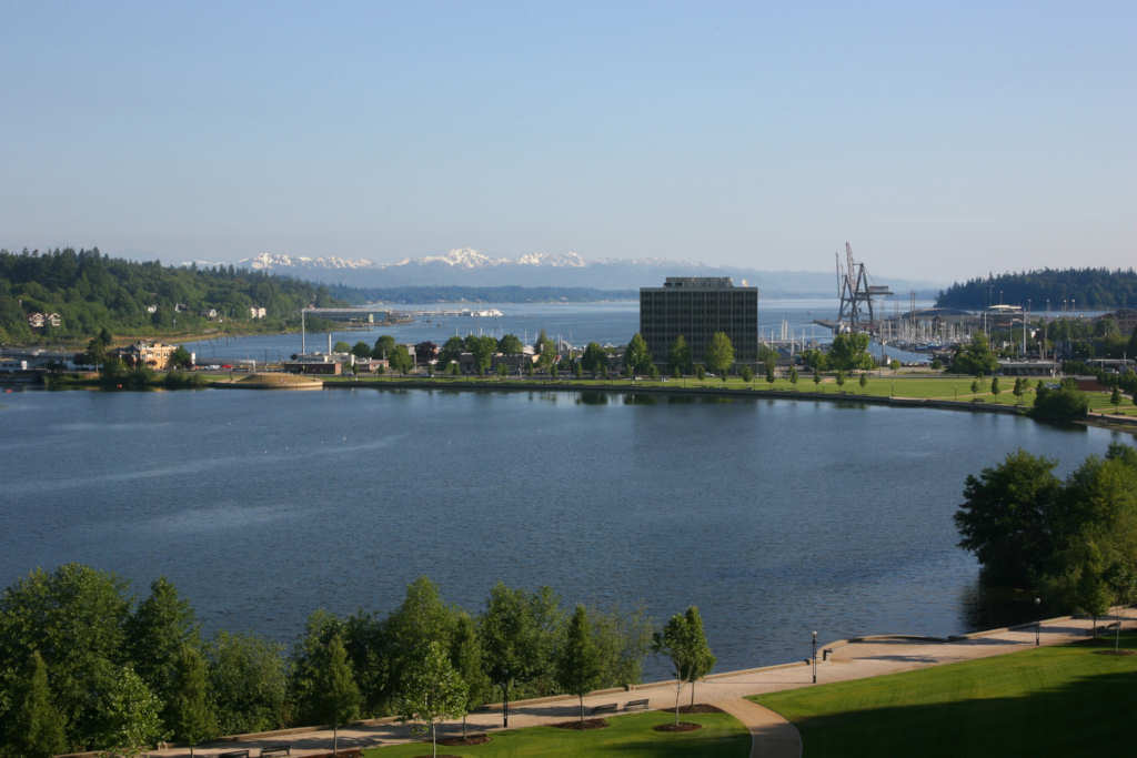
In the early 1900’s, the State of Washington chose an inspired vision developed by Wilder and White for the Capitol Campus. As part of this vision, Capitol Lake was created on the basis of its aesthetic value and ability to transform the downtown into a more vibrant capital city.2
In 1951, the State of Washington created Capitol Lake by constructing the current 5th Avenue dam. The lake consists of the three basins (South, Middle or “Mid,” and North – we capitalize to draw attention to each individual basin). As part of this broader vision, the dam reduced the need for major dredging of lower Budd Inlet to maintain water depths needed for navigation, and as a result the city waterfront began evolving into its present form. Our State Capitol Campus quickly became a national and state-wide iconic treasure.
Capitol Lake itself represents the heart and soul of our area, providing a strong sense of community.
Nautical charts from the mid-19th century show that all of lower Budd Inlet was an extensive mud flat at low tide, requiring a mile-long pier to gain access to water depths suitable for navigation. The Deschutes River system produces and delivers approximately 35,000 cubic yards of sediment per year (more or less – for example, significantly more in 2008 and 2009).
During the early 20th century, the first of several major dredge operations occurred. The dredging spoils were used to enlarge and further develop downtown Olympia and the Port of Olympia. Dredging also ensured adequate water depth for navigation purposes.
The sediment from the Deschutes River flowed into lower Budd Inlet prior to the construction of the dam, creating the extensive and growing mud flats. Now, much of that sediment settles into Capitol Lake, with most of the siltation settling into the North basin.
The most recent Capitol Lake dredging occurred in 1986, almost 25 years ago. Dredging in the marina waterfront occurred in the early 1980s and at the Port of Olympia Turning Basin in 2009. The pre-1986 Capitol Lake North basin water depth was about 15 feet, but is currently at about 8 feet. Water depths in the Middle and South basins have declined by 3.6 feet between 1949 (immediately pre-dam) and 2004 due to siltation.
The Department of General Administration (GA), which has been directed by the State Legislature to manage Capitol Lake “as a lake” as part of the State Capitol Campus has completed multiple studies and analyses since the 1970s. There has been no report that has been accepted by the State or any recommendation proposing a change in the status of Capitol Lake as a lake that appears to have gained widespread acceptance by the public.
The “no action alternative” taking place by default since the mid-1980s due to the lack of active management by the State is not and never has been acknowledged by anyone to be an acceptable management practice.
The failure to act by the State is creating an increased liability in terms of overall water quality and sediment management, navigation in lower Budd Inlet, maintenance and preservation of Capitol Lake as part of the Capitol Campus, and use and enjoyment of this asset by citizens.
Authority for Stewardship and Preservation of Capitol Lake
The laws of Washington State, as contained in the Revised Code of Washington (RCW), make it clear that Capitol Lake is an essential part of the state capitol grounds and that the Department of General Administration is responsible for the stewardship, preservation and maintenance of this asset. The pertinent RCWs include:
- RCW 43.34.090 section 4 states: For purposes of this section, "state capitol grounds" means buildings and land owned by the state and otherwise designated as state capitol grounds, including the west capitol campus, the east capitol campus, the north capitol campus, the Tumwater campus, the Lacey campus, Sylvester Park, Centennial Park, the Old Capitol Building, and Capitol Lake.
- RCW 79.24.720 states: The department of general administration is responsible for the stewardship, preservation, operation, and maintenance of the public and historic facilities of the state capitol, subject to the policy direction of the state capitol committee and the legislative buildings committee as created in chapter . . . (*House Bill No. 1301), Laws of 2005, and the guidance of the capitol campus design advisory committee.
- RCW 79.24.530 states: The department of general administration shall develop, amend and modify an overall plan for the design and establishment of state capitol buildings and grounds … in accordance with current and prospective requisites of a state capitol befitting the state of Washington. The overall plan, amendments and modifications thereto shall be subject to the approval of the state capitol committee.
In 1997, a multi-jurisdictional advisory committee known as the Capitol Lake Adaptive Management Plan (“CLAMP”) Steering Committee was established to advise GA’s Director on management of the lake. The committee shifted direction and focused its effort primarily toward advocating for the reversion of the area into tidal mud flats, at great immediate expense, over the next 50 to 80 years. The findings from this effort are problematic and numerous. In the following section we will outline some of the more significant issues.
Purpose, Background & Authority for Stewardship - CLIPA White Paper
by: CLIPA Capitol Lake Improvement & Protection Assn.Purpose, Background & Authority for Stewardship, part of the CLIPA White Paper, a plan for ongoing management of Capitol Lake in Olympia, Wa.