
COMMUNITY WATERFRONT MANAGEMENT PLAN
A Balanced Community & Environmental Management Program
A Hybrid/Split Lake with Restored Estuary and Waterfront Plan
July 30 , 2018BRIEF BACKGROUND
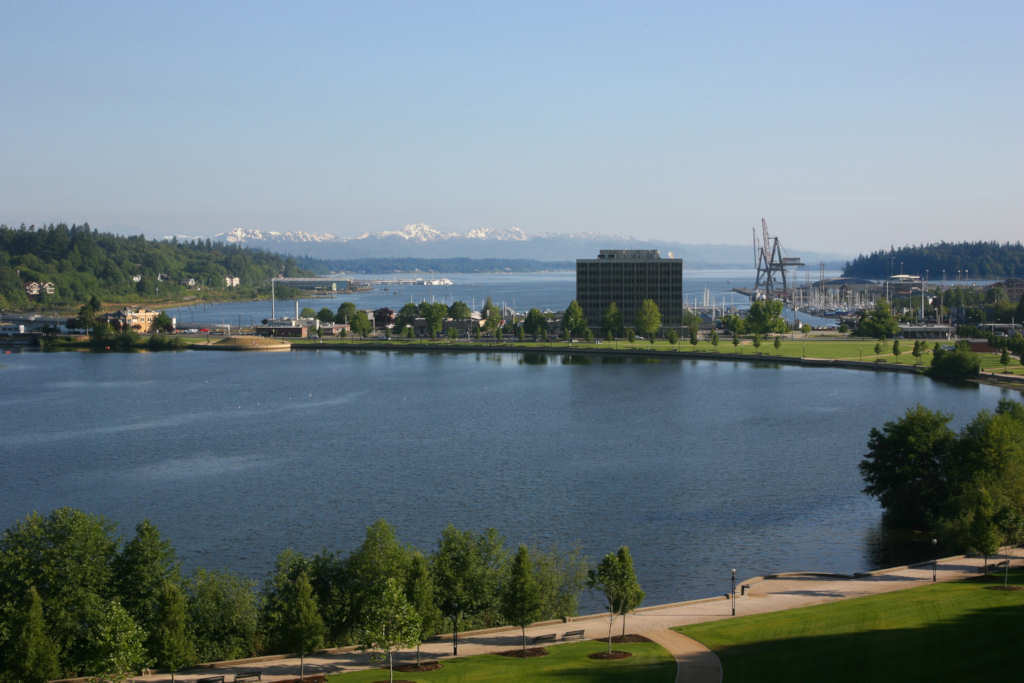
The Deschutes River Urban Watershed, extending from the Pioneer Park area near Henderson Boulevard to Priest Point Park in lower Budd Inlet, is the premier active community area for almost 300,000 residents of Thurston County. The population of Thurston County is projected to grow to almost 500,000 people over the next 25 years. The community and state government plan for this “front yard” area will impact the quality of life, the economic future of its citizens and importantly, the urban environment. A properly managed shared use of this vital area is imperative.
In May 1999 the then "Final EIS", for the Capitol Lake Adaptive Management Plan was prepared by the State DES/General Administration and the Thurston County Regional Planning Council. Five Alternatives were evaluated, plus a sixth "no action alternative". The focus, benefits and costs were limited primarily to the perspective of the State of Washington, and limited to only the Capitol Lake.
Little attention was given to the impacts of the Capitol Lake Management on the larger Thurston County community. Particularly significant omissions included how to manage the sediments, the economy of the Downtown Olympia area, and how local/state governments will fund the plan’s implementation.
Early in 2000, a new group, the Capitol Lake Adaptive Management Plan (CLAMP) team contracted with the State's Department of General Administration (now DES) for about $3.0 million in State funded new studies to evaluate three of the 1999 Alternatives, inexplicably leaving behind two of the hybrid Lake Management alternatives.
WHY A BALANCED "COMMUNITY PLAN"IS NEEDED
In 2016 the DES' Capitol Lake Long-Term Planning Group, consisting of the Cities of Olympia & Tumwater, Thurston County, the Port of Olympia & the Squaxin Tribe, reformatted the work of CLAMP, continuing to ignore most of the alternatives and work included in the 1999 EIS. Important considerations regarding impacts to the entire community were often only partially included or simply excluded.
With meaningful input from informed community members being severely limited, this government group recommended that another EIS costing $5 million be funded by the State Legislature. The 2018 Legislature partially funded that request. Therefore, it is imperative that the State Legislature and agency leaders understand what the community desires.
As it now stands, information provided to the Legislature from the 2016 DES/local process does not adequately include community needs or priorities as specifically defined by community stakeholders. Hence, a more balanced community plan is required. Note: Readers requiring confirmation that community needs are being disregarded are directed to the DES Long Term Planning Executive Work Group’s “Purpose and Need” document.
NOTE ON THE ECOLOLGY DESCHUTES RIVER/BUDD INLET TMDL
Concurrently with the State Capitol Lake review, the Department of Ecology has continued to work on the federally (EPA) mandated Total Maximum Daily Load (TMDL) analysis, which links all impacts in the Deschutes Urban Watershed into one ecosystem and related water quality management plan. Obviously, the upper rural sub-watershed of the Deschutes River impacts the downstream Urban Watershed. Thus County and city land use and utility service regulations that continue to provide for discharges into the water ways, impact the entire system downstream to Puget Sound.
The primary focus of Ecology are the water quality issues identified in Puget Sound and to suggest to DES in general terms how to improve the watershed water quality today and in the future. Of special note, in June 2018, EPA notified Ecology that it has rejected/not approved the Ecology recommended TMDL plan for the upper watershed, due primarily to Ecology's failure to adequately involve the public in the review of the proposed plans that will impact all citizens of Thurston County.
A PROPOSED WETLAND, ESTUARY, LAKE PLAN FOR THE COMMUNITY WATERFRONT
This proposed Wetland, Estuary & Lake Plan (COMMUNITY WATERFRONT MANAGEMENT PLAN) is a hybrid of all of the best elements of the previous studies and builds on one of the two 1999 DES/GA EIS Alternatives. It incorporates the findings of the STATE/CLAMP/COE (Corps of Engineers) Consultant Studies related to sediment management and infrastructure requirements. It adds the potential to restore the only natural salmon spawning stream (Percival Creek) in the Deschutes River watershed and protects species that are under consideration for protection under the Federal Endangered Species Act. This plan is by far the most consistent with the Ruckleshaus Commission’s recommendations.
This PDF map is 11"x17". To print, adjust appropriate printer settings.
The infrastructure, restoration, and larger urban watershed program can be adaptively built in phases to accommodate funding and future local government sea water rise protection strategies. It also provides for several tribal and other cultural centers of development to reflect all of the rich history of the Urban Waterfront and State Capitol Campus.
See the ATTACHED MAP (PDF 1 page) of the "PROPOSED COMMUNITY WATERFRONT MANAGEMENT PLAN" super-imposed on an actual photo of the Urban Watershed. The Map shows both the existing sources of contamination impacting the Budd Inlet area of Puget Sound, and the key new community projects that will make this COMMUNITY WATERFRONT MANAGEMENT PLAN an implementable program for the entire community in the near future. The following further describes the key elements of the COMMUNITY WATERFRONT MANAGEMENT PLAN.
DESIGNATE THE MIDDLE AND SOUTHERN BASINS OF CAPITOL LAKE AS WETLAND
Convert the Middle and Southern Basin (approximately 2/3 of the Capitol Lake basin) to a managed and enhanced wetland natural treatment system with a middle basin sediment trap (optional) designed to protect the Yuma Myotis Bat Population, provide wetland waterways to historical tribal village sites, and for wildlife observation and community outreach. The North basin (north of the Lake railroad trestle) would serve as the primary sediment trap and natural water quality treatment (similar to the LOTT's multi-million dollar nitrogen removal system--but with virtually no public cost).
Additionally, this system helps to accommodate waste products from the existing and proposed fisheries enhancement projects while providing the most popular urban family recreation objectives of the community, swimming and boating in the North Basin of the Lake.
THE SEDIMENT TRAP/MANAGEMENT SYSTEM
As documented by CLAMP, over 400,000 cubic yards of existing sediment build up will be required to be removed from the Lake and marine water area to start any project except "No Action". A permanent (mostly hidden) hydraulic dredge system would be installed to periodically remove (uncontaminated)River sediment (35,000 cu yards are transported by the River annually) via a hidden dredge to the State owned staging area west of the City of Olympia Pump Station along the Deschutes Parkway for de-watering and reuse for public landscaping. Dredging and expensive upland deposition from the legacy contaminated marine waters in Budd Inlet will only be required rarely for deep water shipping.RESTORATION OF ESTUARIES
The COMMUNITY WATERFRONT MANAGEMENT PLAN would remove the west shore Budd Inlet railroad bridge and berm connecting West Bay Park with the 4th Ave area and complete restoration of that area into a mud flat estuary similar to that recommended by the pro estuary plans.
Additionally, the Plan would install a boardwalk extension along the toe of the west side bluff between the 4th Ave area and the Park and restore another mud flat estuary at the south end of East Bay (south of Swantown Marina.
FOSTER AND PROTECT SALMON HABITAT
The Plan allows the Middle & South Lake Basins to serve as highly productive wetland ecosystems which provide habitat for aquatic insects (critically important for our Yuma Myotis Bats, juvenile salmon and other aquatic species). The basin will continue as a transition area for salmon returning to the proposed Deschutes hatchery (the new multi-million dollar fish hatchery at Pioneer Park to enhance the man made Deschutes River Salmon fishery). The Plan will allow the continuation of minimal compression points (water body narrowing) thus reducing severe marine mammal predation of salmon which would occur with removal of the tide locks. Removing the 5th Avenue dam would triple the number of predator compression points.WATER QUALITY ISSUES & TREATMENT
Department of Ecology and EPA 303d listings for the upper Deschutes River, Capitol Lake and Budd Inlet are out of date. Recent comments on water quality violations are generally based on field sampling programs completed 20 years ago by State consultants. Almost all of the contaminants found in Capitol Lake come from the upper watersheds. New contaminants will be added to the Deschutes River from the proposed Pioneer Park Fish Hatchery and expansion to the Tumwater Falls Park Holding Ponds.
Therefore the contaminant load attributed to Capitol Lake which is measured at the outlet of the Lake at the 5th Ave tide locks, originate from the 80 or more local and State storm water discharge pipes, WDFW fish holding & rearing ponds, golf course run-off, livestock, failing septic tanks in the Olympia, Tumwater & County residential areas, road run off from I-5, State and local government roadways and upper watershed farm and forestry land. Capitol Lake is currently serving as a “natural nitrogen (and Carbon) and phosphorous treatment sump for the upper watershed” attaching to the sediments in the Lake and reducing the contaminant load prior to flowing into Budd Inlet.
PLANT HARVESTING TO REDUCE CARBON LOADING IN BUDD INLET
This plan would include plant harvesting at an interval necessary to significantly reduce the Ecology focused Carbon contaminant load from the upper watershed and urban storm water run offs into Budd Inlet. Additionally, harvesting will significantly improve summertime Capitol Lake aesthetics.
SAFETY HAZARDS OF A RE-CREATED MUDFLAT
If the tide gate is removed, the Lake Basin will become a twice daily mud flat with high velocity discharge into Budd Inlet. Carcinogenic contaminants, currently affecting Budd Inlet sediments will spread throughout the entirety of the Capitol Lake Basin. Additionally, as noted by the Thurston County Health Department, mudflat sediments may entrap humans and animals. The Community Plan would preclude this new community problem in the heart of our downtown.
Coho Restoration Project
With the exception of modest spawning in Percival Creek, there has never been significant sustainable spawning of native or wild salmon in the entire Deschutes River watershed, including the Capitol Lake basin. This is primarily due to the existence of Tumwater Falls as an upstream migration barrier. (Salmon do not spawn in saltwater.)
Although Percival Creek’s spawning habitat has been seriously harmed by human development in its upper reaches, CLIPA’s proposed “Coho Habitat Restoration Project” in lower Percival Creek could help to provide a modest sustainable fishery for wild coho, and possibly steelhead and chum in this watershed. The plan is simple: provide ample woody debris and engineered log jams strategically in Percival Creek. WDFW should decide if adequate spawning habitat still exists in Percival Creek to support the cost of this project.
Percival Creek Extension Plan
Percival Creek currently empties into Capitol Lake. Some have speculated that a direct access from Percival Creek to Budd Inlet could possibly benefit easier passage of juveniles and adults into and out of this waterway. A sinuous meandering channel just west of the current north basin of Capitol Lake and emptying into the southwest corner of Budd Inlet could accomplish this.
Tidal flows for improved ingress of stray juvenile salmon (from watersheds other than the Deschutes) for rearing might possibly be increased by this re-channeling. As for the Coho Restoration Plan, WDFW should evaluate the wisdom of this strategy.
TRIBAL CULTURAL CENTERS AND COMMUNICATIONS
The Plan would set aside the south end of West Bay Park (next to Rotary Point Park) or a portion of the North Capitol Campus Heritage Park, area for the Squaxin Tribe to construct a Cultural Center/Museum/activity area. It would provide for a traditional canoe “portage route” under the 4th Ave Bridge/crossing the new Percival Creek waterway to access the Lake and wetlands in the Middle and South Basins. A similar portage could be built around Tumwater Falls. The Plan could provide for a Tribal Communications/Site near Percival Cove, near the Mitigation Area at the South end of the Middle Basin and a Steh-chass village at the bottom of the Tumwater Falls. All Tribal Communication Areas & sites could be a continuation of the Squaxin and Nisqually tribal programs in Budd Inlet.
PHASED CONSTRUCTION, COSTS AND MANAGEMENT
This Community Management Plan is a Hybrid/Split Lake/Restored Estuary/Community Waterfront Plan that can be constructed in phases (in contrast the Estuary Plan/Removal of the 5th Ave Tide gate alternative would require a 90% Completion to function). This Community Waterfront Plan of Projects when completed would cost about 10% of any alternative that removed the 5th Ave Tide Gate or about $40 million versus $400 million over 20 years.
This cost savings could be applied to projects far more productive in terms of salmon habitat rehabilitation and water quality improvement in other Puget Sound areas. Annual operating costs for this Community Plan would also be about 5% of the Estuary/Tide Gate removal alternative. Cost sharing and management will be a Local/State/Tribal/Federal Cost. If cost sharing is to include property owners, the Plan will require some form of a Special District where the local, State, Tribal and private business stakeholders share in the costs and have representation on the Management Board.
SEA WATER RISE PROTECTION AND MANAGEMENT
Sea Water rise strategies for the Downtown Olympia area are still under discussion. Sea Water rise problems are a phased response requirement, but the design is required soon to ensure that the Downtown Redevelopment follows a program based on long term policies and investments. The sea water rise is a “scheduled tidal rise issue” that is approximated by the current “Deschutes Flood Stage and King Tide Events” that are somewhat predictable and can be managed, if proper plans are in place.
Continuation and enhancement of the Downtown Flood Protection Program currently provided by the DES management of Capitol Lake Tide Gate Operations is the least cost “first line of protection”. Protecting the Downtown area north of the Lake will involve modification of the core area, most likely a combination of a seawall and an elevated roadway/berm in selected areas. The cost of the Sea Water Rise Protection District or by the City should be a cost and design consideration in the future plans of the Tide gate/Capitol Lake EIS.
INVASIVE SPECIES MANAGEMENT
The New Zealand Mud Snail are found in over 30 locations in Western Washington, including the Lake Washington Watershed. Other than Capitol Lake, none of these aquatic areas have been closed to human use. The most recent review of the Capitol Lake Mud Snail population suggests that they are now being controlled by natural predators. The snails survive in brackish and freshwater, suggesting that their future control management will be required under all alternatives for the Lake.ENDANGERED SPECIES MANAGEMENT
Species residing in Capitol Lake (such as the Olympic mudminnow) are under consideration for protection under the Federal Endangered Species Act. Removal of the Lake will require a compensated response for restoration of these species.
The endangered Orca whales require plentiful numbers of Chinook salmon for their survival. Our Southern Puget Sound pod is in serious difficulty largely due to low numbers of Chinook. Under the current Capitol Lake and ladder system, millions of Chinook have been reared to provide sustenance to this endangered species. As noted above, removing the dam would triple or quadruple the number of predator compression points, likely reducing those Chinook numbers.
SUMMARY OF BENEFITS AND ADVANTAGES
The proposed Community Waterfront Plan provides specific benefits and advantages to the Community and Environment when compared to other alternatives being considered. Again, no other Lake management plan fits as well with the spirit of the Ruckelsshaus Center recommendations of 2014. Through compromise and creativity, it provides a remarkable system which balances the values and needs of our environment and the vast majority in our community.
Some specifics follow:- 1) The Plan is a hybrid of the best attributes of all alternatives being considered. These best attributes include scientifically based juvenile salmon rearing enhancement, estuary acreage restoration, massive wetland creation, and water quality improvement in Budd Inlet.
- 2) Preservation of the enormously valuable aesthetic and social cohesion benefits held by the community. These benefits add to the community's quality of life without causing environmental damage.
- 3) The Plan can be built in phases to ensure that design decisions with the intent of improving Budd Inlet water quality can be confirmed before proceeding to the next phase. It is a cost effective and adaptive management plan.
- 4) The Plan provides excellent family recreation in the North Basin, wildlife observation and outreach in the Middle and South Basins, and natural protections of all species of concern.
- 5) The Plan's cost is only about 10 % of what it would cost to remove the 5th Ave Dam and 5% of the on-going maintenance cost associated with retention of the Olympia Waterfront as a family and business oriented boating waterfront.
- 6) Savings in the hundreds of millions of dollars could be used for more productive purposes such as rehabilitation of salmon spawning and rearing habitat (particularly 2,000 culvert restoration needs) and prevention/reduction of storm water and toxic run-off into Puget Sound.
- 7) The Plan has been endorsed by all individuals that understand the pros and cons of the primary alternatives as a "workable, doable, and affordable Plan" for all citizens of Thurston County.
- 8) This Plan respects the Tribal and Historical uses of the Urban Waterfront and will allow all citizens of Thurston County to join together to develop historical sites that respect and embrace our collective history of our community.
- 9) This Plan avoids the public health and safety problems associated with dam removal.
- 10) Lastly, this plan would allow Budd Inlet shoreline businesses to continue. This attribute is of utmost importance to a healthy downtown.
See Dr. David Milne's Critical Review of the Department of Ecology Supplemental Modeling Scenarios Report
See CLIPA document Introduction to the Hybrid Management Plan and the PDF Map showing the Proposed Plan
Save or view PDF version of this document ( PDF 6 pg )
Hybrid Community Waterfront Management Plan
CLIPA Capitol Lake Improvement & Protection Assn.