
Lake Maintenance Plan - CLIPA White Paper (part 2)
A Science-based Watershed-wide Maintenance Solution
The recommendations and options outlined in this Capitol Lake maintenance plan represent the ideas originally developed at the “Save Capitol Lake Workshop” assembled earlier in the year by CLIPA. This group had depth and breadth of expertise in biology, ecology, fisheries, engineering, finance/capital budgeting, law, State regulations and EIS process, permitting, policy development and policy implementation.
The group had a strong working knowledge of relevant issues related to the specific management and operations of Capitol Lake over the last 25+ years, and the historical development and decision making around Capitol Lake, as well as generally to riparian areas, wetlands, lakes, and the marine environment.
The ideas presented here are meant to provide options and alternatives that will assist in the State’s decision making process, and to further support the White Paper and Financial Projections included in this packet. As a volunteer group we recognize certain omissions and errors may exist, and while inadvertent, we advocate for a thorough predesign study to ensure the best information is made available prior to design and implementation. We have outlined elements that might be included in the predesign study in the Financial Projections section of the packet.
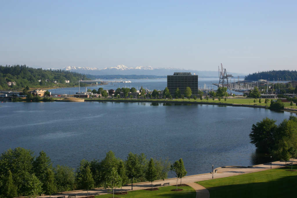
The lake maintenance plan draws heavily from the existing Capitol Lake Adaptive Management Plan Final Environmental Impact Statement (FEIS) of May 20, 1999 option for the “Lake/River Wetland Without Trap Alternative.” A permit for continuing a Capitol Lake maintenance dredging program should be applied for under the authority of this alternative.
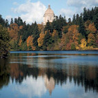
Lake/River Wetland Without Trap Alternative
Under this alternative, the tide gate would remain and there would be no initial maintenance dredging in the South and Middle basins. Under this alternative, these basins would evolve into freshwater wetlands for a period of 50 to 85 years as they filled with sediment from the Deschutes River. As the South and Middle basins filled with sediment, the North basin would be continuously retained as an open-water area by maintenance dredging in the basin repeated every 2 years. (See Attachment A - Image)
Our Stated Position, with Specific Amendments and Options to this Alternative
Our investigation shows that the North basin would only need to be dredged once every 5 years. We recommend and identify funding for a Deschutes Watershed management plan that addresses sediment management upstream as part of a comprehensive sediment management strategy. When implemented, the costs for dredging Capitol Lake could be reduced and the timing could be extended considerably. (It should be noted we are not advocating a shift in costs from the state to the local level, but a cost sharing program consisting of a public/private partnership.)
CLIPA strongly advocates for the restoration and protection of the entire lake, consisting of the three basins (South, Middle or “Mid,” and North – we capitalize each to draw attention to each individual basin). We recognize the State’s inaction to maintain the lake through routine dredges has resulted in the South basin turning into a wetland. We somewhat reluctantly support the continuation of the South basin as a wetland if:
- funds are not sufficient to return this basin into a lake;
- a Deschutes Watershed plan and the predesign studies clearly indicate the benefits of this wetland to the system as a whole, and;
- this wetland be incorporated into an overall watershed and lake strategy to provide for the needs to the ecosystem and community, such that it is properly maintained and enhanced for habitat and other appropriate uses.
CLIPA recognizes the Mid basin has at least three possible courses that it may follow:
- Our preferred alternative of restoring and protecting it in its entirety, which is identified in the funding proposal
- Our next preferred alternative of restoring and protecting the northerly section of it, while allowing the southerly section of it to fill with sediment (naturally and/or as a sediment disposal site for North basin sediment dredging spoils) into a wetland, and to be managed for habitat, recreation, and education as such (the timing would remain the same as in the funding proposal, it would just be reduced to account for the partial treatment)
- The entire loss of the Mid basin as part of Capitol Lake, which we do not support, as outlined in the alternative.
It is important to note that this decision does not need to be made until later in the first decade, after further study, experience from the North basin maintenance dredge, and coordination of a Deschutes Watershed plan.
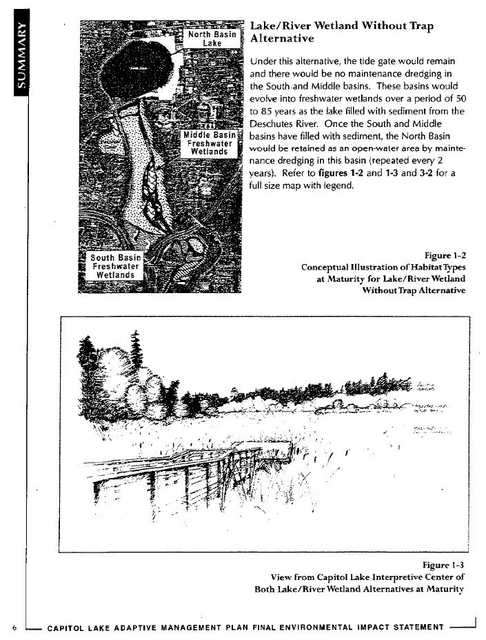
With respect to the latter two alternatives, we first recommend considering Percival Cove as a dredged material disposal site (see "Alternative Considerations" below), but should the Mid basin be (partially) converted into a wetland, we strongly recommend dredging spoils not be placed along the western shore (or either shore for that matter) at any time, as this would preclude the optimal development of a wetland.
Optimal development of a wetland for multiple purposes, whether for part or all of the Mid basin, would suggest creating a south to north “island,” with streams running along either side. A walking bridge could be constructed to access this area once it was built up enough, for the purposes of trails and interpretation.
(See Figure 1 – Maintenance Dredging Method, includes a sketch of option #2 only for illustrative purposes)
Sediment “Trap” Concept
With respect to aspects the predesign study might include, the EIS Alternative “Lake/River Wetland With Trap” should also be considered regarding the “trap” concept. However, a sediment trap located in the Middle basin in the pathway of the moving river current may only have a trapping efficiency of 25% according to the 1997 Entranco Study, and reiterated in the 2008 Moffatt & Nichol Dredging Report (page 36).
We are intrigued as to whether relocating the “trap” to the southerly section of the North basin would provide a more effective and efficient location. In our White Paper and Financial Projections, we consider the center of North basin, and thus North basin itself, to act as the sediment “trap” until further study indicates otherwise.
Recommendation
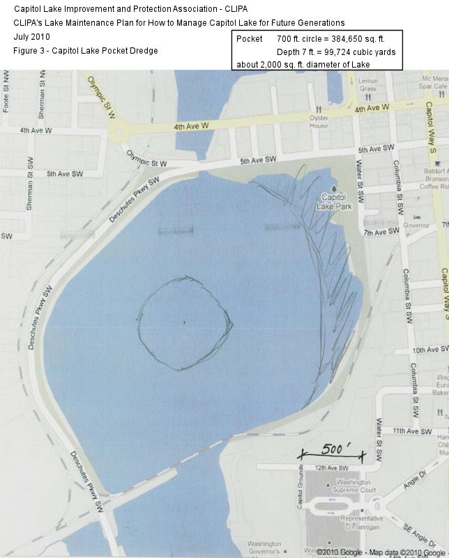
The CLIPA Capitol Lake maintenance study finds that the “maintenance dredge” activity should begin immediately within the Capitol Lake North basin. A prime location for a sediment “fall-out” pocket is where the current no longer flows, which in this lake/river system is in the center of the North basin.
Methods
The maintenance dredging equipment could mobilize in the North basin at either the east edge of Marathon Park or at the extreme southwest end of Heritage Park, both of which are accessed by roadway and adjacent to the railway tracks at each end of the trestle. (See Figure 3 – Capitol Lake Pocket Dredge - Image)
Alternatively, the North basin could be completely drained and allowed to sufficiently dry, such that equipment could enter the basin directly for dredging operations.
These two approaches have the following dredging spoils options:
- A “dewatering staging area” established at the GA acreage located directly west of Marathon Park for future upland distribution;
- Directly loaded into railway cars for overnight dewatering and haul off for landfill caps at various Pacific Northwest locations;
- Transfer the dredging spoils into Percival Cove; or in the southwest corner of the Middle basin where prior dredging spoils were deposited; or contiguous to this area in the southern portion of the Middle basin, to begin creating a wetlands viewing park within the lake. This latter concept likely would require development of predesigned berms at strategic locations. The material would be redistributed into the Middle basin by creating wetland berms, for nature pathways, and additional park area. This set of options eliminates the need for exporting sediment, would have minimal costs, and could be accomplished within a typical “fish-window” timeframe.
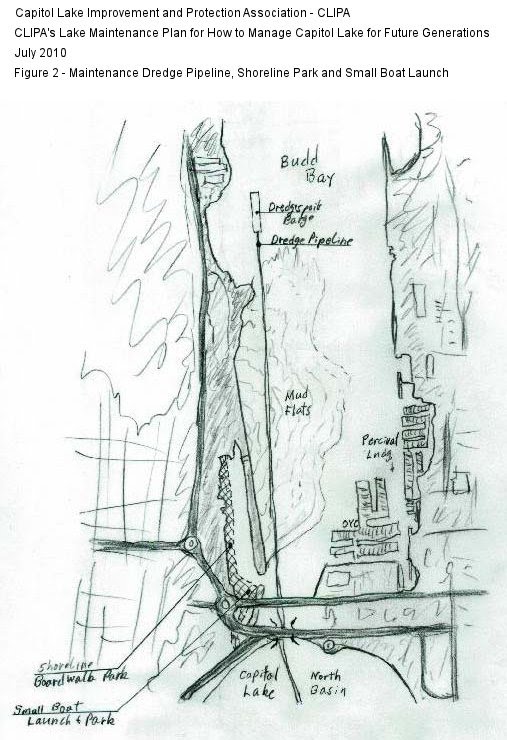
Another option is for piping infrastructure to be installed between the North basin and lower Budd Inlet, through the dam. The North basin sediment would be pumped by tight-line to dredging barges situated in lower Budd Inlet, to be transported to another location. (See Figure 2 – Maintenance Dredge Pipeline, Shoreline Park and Small Boat Launch - Image)
The pre-1986 North basin water depth was about 15 feet and is currently about 8 feet. The maintenance dredging volume to obtain the average depth of 13 to 15 feet (taking into account sloping bank contouring) is estimated to be about 100,000 cubic yards.
Lower Budd Inlet Marine Dredge
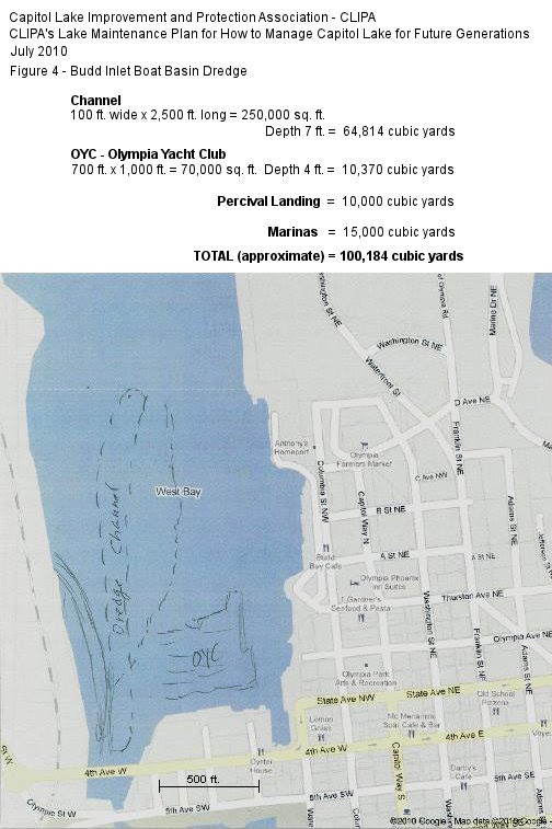
A dredging operation within the lower Budd Inlet and Percival Landing boat basin is also recommended during the first phase dredging scenario, beginning in the first year of the second biennium (2013-2015). The funding request reflects this activity.
This dredging task could be accomplished with various types of dredging equipment and barges, with dredging spoils to be relocated along the western shoreline of lower Budd Inlet for park/boardwalk development. The dredge spoils also could be sent off for deep water disposal (e.g., Anderson Island, or Commencement Bay). (See Figure 4 – Budd Inlet Boat Basin Dredge - Image)
- Dredging within the lower Budd Inlet, including the western section and the boat marinas, must be done to relieve shallow waters that ultimately interfere with navigation. This accumulated sedimentation was created by recent years of sediment drop-out of increased materials transferred from Capitol Lake through the dam during the twice per day drain-downs.
- Dredging of the resultant “mud flats” from this accumulating sedimentation directly north of the dam and west of the Olympia Yacht Club must be dredged to re-open the “flow-channel” into the northern inlet. (See Figure 4 – Budd Inlet Boat Basin Dredge - Image)
- This mud flat area created by lack of State maintenance to Capitol Lake is resulting in a blockage of the natural northerly current flow of water being drained from Capitol Lake each day, and redirects the current and sediment easterly and directly into and through the Olympia Yacht Club moorings.
- The eddying effect also results in accumulating sediment being deposited into the water-dependent areas including Percival Landing, Martin Marina, One Tree Marina, Fiddlehead Marina, Percival Plaza, and the Port of Olympia. The unintended consequences result in impeding navigation and accumulating sediment deposition under a water-dependent use (the marina moorings).
Alternative Considerations for Dredging Spoils
Alternative considerations for the use of future lake maintenance dredging spoils and/or Budd Inlet dredging spoils are:
- Transport spoils to Percival Cove to create wetland viewing areas, pathways and parklands by strategically placing dredging spoils within the cove area. (This option is preferred over placing the dredging spoils within the Middle basin area.)
- Transfer spoils to Budd Inlet west bay shoreline for boardwalk and park development by the City of Olympia for its West Bay Waterfront Park plan.
- Transfer spoils to create a shoreline boardwalk and park-strip area along the extreme west side of the Budd Inlet lagoon located just north of the new 4th Avenue bridge. Currently, the steep bank ends abruptly into the lagoon water’s edge without an upland “land-bridge” for cross access. A bulkhead and sediment backfill could be used to extend the future park-strip and boardwalk to benefit the City of Olympia’s interest.
- Create a park and water’s edge “launching area” into the lagoon for access to Budd Inlet by canoes, kayaks, and similarly-sized boats. A drive access to this area could be created from the north end of Deschutes Parkway under the 4th Avenue and 5th Avenue bridges on the west side.
- Transport spoils to Budd Inlet for loading onto barges and disposal at a deep-water disposal site.
- Consider creating an “up-river” dredging pocket area for periodic easy access maintenance dredging to capture and remove sediment prior to entry into the lake system. These dredging spoils could be dewatered at the dredging site for later truck hauling to landfills, quarry reclamation, landscape use, etc.
- A possible location is within the Olympia brewery and City of Tumwater properties. The DeschutesRiver flows through south of the brewery and north of the Tumwater Valley golf course. Large brushy riverfront acreage exists at this location.
We recommend that the issues of Capitol Lake water quality such as fecal coliform, dissolved oxygen, temperature, pH, and turbidity may be better addressed with the up-river sediment management approach.
We also recommend that the current purple loosestrife eradication program be aggressively continued to its extinction within the Capitol Lake system.
Attachments
Lake Maintenance Plan - CLIPA White Paper (part 2)
by: CLIPA Capitol Lake Improvement & Protection Assn.Lake Maintenance Plan for How to Manage Capitol Lake for Future Generations - A Science-based Watershed-wide Maintenance Solution. Part 2 of the CLIPA White Paper