
The Nature of Capitol Lake
Prepared by Kaye V. Ladd; PhD and Oscar H. Soule; PhD - July, 2011
1. Is Capitol Lake a fresh water lake? No!
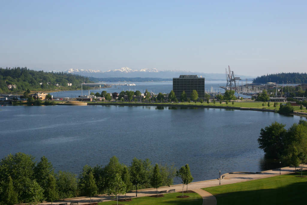
Capitol Lake is a typical estuarine tidal basin created by the configuration of the exit of the Deschutes River to Southern Puget Sound. This exit is very narrow in diameter and is currently located at the 5th Ave dam. This configuration causes high volumes of river water (fresh water) and high volumes of high tide salt water from Puget Sound to fill the area upstream of the exit.
Thus, there is a flow of fresh water out of the Capitol Lake area and an inflow of salt water into Capitol Lake with a net “lake” of water left at high tide or high flow of the Deschutes. Were there no dam, or when the dam gates are left open during the summer low tides, there is little to no “lake”. Instead there is a mud flat that follows the conformation of Capitol Lake; i.e. the mud flat is roughly circular.
2. What is the purpose of the dam at the 5th Ave Bridge?
The purpose is most likely to provide a lake type body of water “Capitol Lake” during the summer low tides and low volume of the Deschutes River and regulate the water height within Capitol Lake the rest of the year. Without the dam, during the summer low tides, Capitol Lake would not exist. On occasion, the gates to the dam have been opened during the summer low tides and the water flows out leaving a roughly circular mud flat which follows the conformation of Capitol Lake.
Depending upon the drought levels, the Deschutes River is a thin stream through this mud flat offset toward the Deschutes Parkway side of the “Lake”. The mud is the type that sucks the shoes off your feet should you try to walk on it.
During the wet winter, the dam gates are left open so the combined flow of a flooding Deschutes River and Puget Sound high tides do not flood downtown Olympia, particularly in the region between the Deschutes Parkway and Water Street. During other parts of the year, the exit of water is controlled to keep the level of water in Capitol Lake somewhat constant. However, observation shows some tidal variation within the lake and different water levels on either side of the dam.
3. Is this dam a traditional river dam? No!
With normal river dams water flows in one direction, downstream. With this dam, water can flow in both directions. When the dam gates are open, river water flows out and salt water from high tide flows in. Because it is denser, the salt water generally flows in under the lighter fresh water which is flowing out. If conditions are right, salt water can actually push the fresh water upstream.
This phenomena is observed routinely in the Bay of Fundy, Nova Scotia. When the dam gates are closed river water flows out through the bottom of the dam. Because it is denser and pushed by tidal forces, salt water can flow in though this same passage.
4. Is sedimentation in Capitol Lake caused by the same processes as in traditional river dams? No!
With normal river dams, the static water at the dam gives the silt load a chance to settle out. This is not the process occurring within Capitol Lake. Capitol Lake is a tidal basin and is undergoing normal sedimentation from the mixing of fresh and salt water. A standard way to improve the precipitation of colloids and particulates in the laboratory is to add a salt. This dissipates the electrostatic charge between particles, enabling them to aggregate and fall out due to gravity. Such a process occurs on a much larger scale within the tidal basin.
Consider the Deschutes at full flood with particulate loaded water. You can see this situation during our rainy winter.
- The dam gates are open and the brown Deschutes plume is visible past West Bay Marina.
- On an outgoing tide there is little mixing within the basin (Capitol Lake).
- The plume mixes with salt water and the sediments aggregate more and begin to settle.
- The tide changes and some of these sediments are brought back into the tidal basin to settle within the basin.
- Furthermore, the incoming tide mixes with the river water within the basin.
- Particulates aggregate and settle within the basin because they are constrained by the incoming tide and the narrow exit to the tidal basin.
Due to tidal action there is little to no scouring within the basin. The bottom becomes coated by the rain of particulate matter. With coat after coat you get a layer of mud. If the opening to the tidal basin is wide enough you get a delta. Because the opening is constricted, the tidal basin gradually fills in with mud, so dam or no dam Capitol Lake will fill with mud. This is a perfectly natural process which creates an anoxic condition at the bottom of the tidal basin. Aerobic life get smothered, anaerobic life prospers.
5. Will removal of the dam change the rate of sedimentation? Possibly.
To answer this question, you need sedimentation measurement within Capitol Lake. Put out sediment traps for a year with the dam gates and flows at their historic setting. Open the dam gates for a year and make the same measurements.
6. Is there a danger in not dredging Capitol Lake? Yes!
Consider a rainy winter with the Deschutes at full flood, a very high tide, and a Capitol Lake with twice as much bottom sediment as now. Right now the Lake is 1 to 2 feet below the wall around the lake under full flood and high tide. With twice as much sediment, the Lake would overflow. Given that Water Street is downhill, much of the overflow would go in this direction. Businesses and roads would be flooded and Heritage Park would be severely impacted.
There is an historic, local analogy. High winter tides blocked the flow into East Bay of Moxlie and Indian Creeks resulting in periodic flooding at the corner of Plum and Union for years. This was solved by moving the pressure release point from that point to positions higher on the creeks. This option does not exist for the Deschutes.
7. Is it appropriate to compare the Deschutes Basin with the Nisqually Delta? No!
Both the Nisqually Delta and Deschutes Basin are estuaries as part of the greater Puget Sound Estuary, but their characteristics are very different.
- The Nisqually River is much larger and is glacier fed; giving it much greater regular flow. The Deschutes River originates in the Gifford Pinchot and passes through very different soils.
- A greater difference is the Nisqually is fronted by a trench with rapidly moving water which disperses the load it carries. Certainly some material coming out of the Nisqually ends up in the Deschutes Basin, but little to no material from the Deschutes ends up in the Nisqually Delta.
- The Deschutes flows into the shallow extremity of Puget Sound which has a history of collecting silt proven by the lengthy wharves required in Olympia’s early history to reach deep water and the steady build up of silt and sand over the years requiring periodic dredging.
- The Nisqually has an open, flat tidal basin which has formed a delta through the salt water/fresh water sedimentation process described above. The estuary has enough open space to mitigate a flooding Nisqually.
- The Deschutes has a restricted exit, which leads to filling of the tidal basin. Furthermore, the Deschutes tidal basin is surrounded by the city of Olympia making no open space to mitigate flood waters.
8. Is there an appropriate estuary for comparison? Probably, but the topic requires research.
A quick survey suggests that estuary formed by the confluence of McLane Creek and Mud Bay might work. This estuary is part of the slow moving Puget Sound and it is clear that it is filling with mud. However, the volume flow of McLane Creek is much smaller than the Deschutes and the exit into Mud Bay is not restricted and there is plenty of room for flood waters. It does give a useful contrast to the Nisqually because it is just mud flats and does show that mud flats are a natural development in some estuaries.
9. Would Capitol Lake as a mud flat be esthetically pleasing? Probably not.
Mud flats are anaerobic environments. Chief among the organisms are bacteria which reduce sulfate to sulfides. The problem for humans is that one of the sulfides is hydrogen sulfide which not only smells bad, but it is toxic to humans.
10. Is removing the dam cost effective? Probably not.
Whether or not the dam is in place, Capitol Lake will fill in and create flooding problems. Thus Capitol Lake will have to be periodically dredged. There is also the cost of removing the dam and constructing a new 5th Ave bridge. At a much greater expense, the Deschutes exit at 5th Ave could be widened, but probably not enough to prevent flooding as Capitol Lake fills in. To prevent flooding the width would have to approximate the width of Capitol Lake. All this to replace the “Lake” with a mud flat at low tide.
11. Does the existence or non existence of the 5th Avenue dam affect the water quality of the Deschutes estuary?
Probably not. The nutrients in the Deschutes River derive from runoff, erosion, fertilization along the banks, and, probably leaky septic systems up river. The existence of the dam does not change this. The salt composition of Puget Sound is dictated by dilution of the normal composition of sea water. The nutrient composition derives from the totality of Puget Sound as an estuary.
Again, the existence of the dam does not change this. The dam merely retards the flow of water both in and out of Capitol Lake so it does affect mixing. When the gates are open, the dam does not even do this.
12. Is there a value to the community in keeping Capitol Lake? Yes.
The values of keeping Capitol Lake a reflecting basin are both economic and esthetic. Currently thousands of visitors use the basin for recreation on an annual basis. These uses include exercise, various types of family and personal outings, and community events. None of these will be enhanced by a mudflat replacing the reflecting basin. Likely all of these uses will be diminished and not replaced by those drawn to a more “natural” setting.
The loss of patrons to adjacent shops and restaurants will be real. The potential for increased use will not balance the loss. River mouths turned into permanent lake-like parks are attractive amenities in cities throughout the US and Europe. We have all seen the Boston Pops playing in the park along the Charles River in Boston. The location of these concerts is about ½ mile from the dam on mouth of the Charles River that makes the Charles lake-like.
CONCLUSIONS
Any long term plan without periodic dredging is short sighted. Southern Puget Sound has required periodic dredging to maintain marine commerce and this will not be reduced by removal of the dam.
Olympia began a Faustian bargain when it filled part of the Sound to create land for development. These uses have become a fixed part of life in this community. Capitol Lake has become part of this overall picture.
The idea is that recreating a mudflat in place of Capitol Lake will not improve the water quality of southern Puget Sound or provide meaningful habitat enhancement in terms of the region. Instead, it eliminates a valued community amenity.
The Nature of Capitol Lake
Kaye V. Ladd; PhD Brandeis University
The Evergreen State College 1975-1995, Emeritus Member of the Faculty-Chemistry
Oscar H. Soule; PhD, University of Arizona
The Evergreen State College 1971-2004, Emeritus Member of the Faculty-Ecology