
Review of Estuary Infrastructure Costs
Prepared by Charles Gloyd, P.E. - August, 2011
Review the Infrastructure Portion of CLAMP alternatives,
and determine if the scope and estimates are reasonable.
- Deschutes Estuary Feasibility Study Technical Report – Engineering Design and Cost Estimates (2007)
- Capitol Lake Dam Condition Assessment and Life Expectancy (2008)
- Capitol Lake Dam Condition Assessment and Life Expectancy Appendices A-E (2008)
- Independent Technical Review (2007)
Highlights of this Review
The estimates made by Moffatt & Nicholl for CLAMP are in general not unreasonable as a planning type estimate, based on conceptual level design. However, the estimates for certain items are very approximate, even crude. A large contingency factor is in order, perhaps the 30% used is insufficient.
The use of a 3 level estimate format is misleading, as it implies more sophistication than is possible at this time. Not enough detail is known to evaluate the likely variation in quantity or the range of risk, as the estimators had very little to base the numbers on. \A single best estimate, with a suitable contingency factor, is a more appropriate format at this stage.
My review is limited by lack of details on the infrastructure items, existing and proposed, and lack of estimating resources. However, my review has identified certain shortcomings in the conceptual design of the tidal basin alternatives, and a few line items that may be in error or otherwise inappropriate.
My most significant finding is that the concept for realigning Deschutes Parkway and reconstructing 5th Avenue represent a significant reduction in the usefulness, aesthetic quality, and safety of the overall facility. I believe that the design suggested by CLAMP for the tidal basin alternatives would not ultimately be acceptable to the community, and that to provide an acceptable design the cost will be substantially greater than CLAMP has estimated. I have made an estimate based on my own concept of an acceptable design.
Problems with the CLAMP design are as follows:
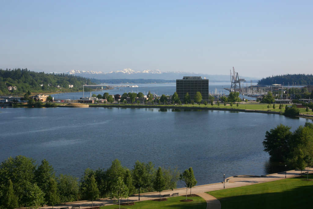
The Deschutes Parkway alignment is changed considerably - it no longer stays at lake level. The parkway climbs up a new embankment to join 5th Avenue near the roundabout, a 30 feet or so elevation gain imposed on pedestrians and bikers as well as automobiles. This changes a level pedestrian facility around the lake to one with a hill to climb, a negative factor for many users.
The Deschutes Parkway intersection with 5th is a Tee Intersection very close to the roundabout, yet has no traffic signals and no turn lanes on 5th Avenue. Traffic is permitted to turn left (west) on 5th Avenue, but must wait for clear traffic in both directions on 5th. This traffic movement is less safe than the existing route which can use signaiized intersections on 5th and 4th Avenues to head west. Signals could not be used at the proposed intersection as it is too close to the roundabout and would create congestion by backing traffic up into the roundabout. Westbound traffic on 5th Avenue wanting to turn left onto Deschutes Parkway has no dedicated turn lane to use while waiting for a safe opening to cross the eastbound traffic lanes. This creates hazards to other westbound traffic on 5th. Overall the proposed design is a negative change for automobile traffic safety.
The new 5th Avenue bridge estimate is based on a utilitarian type of structure, not an appropriate structure type adjacent to the very aesthetic new 4th Avenue bridge which was designed to resemble the previous arch span bridge. The new bridge is proposed to carry four lanes of traffic, compared to two lanes on the existing 5th Avenue bridge. This may be needed because the new bridge will also be carrying Deschutes Parkway traffic.
To minimize foundation scour risk, deep foundations using drilled shafts are proposed for the 5th Avenue bridge. The higher cost of this type of foundation has not been factored into the cost estimate. A more appropriate design would be a bridge of the same architectural style as the existing 4th Avenue bridge, and a separate lake level Deschutes Parkway bridge to provide the same type of pedestrian and vehicle access around the lake as currently exists. A low level Deschutes Parkway bridge can be of a utilitarian type as it is not as visible as the higher level 4th and 5th Avenue bridges.
The plan requires roadway fill and expensive retaining walls along the west shore line. High fill and retaining walls are not desirable aesthetically. Soil conditions in this area are not well suited for high embankments and retaining walls, thus higher costs are likely to strengthen the soil under the high embankment and to provide deep structural foundations for the walls.
The CLAMP plan roadway fill covers the current rail corridor. Although it may be abandoned now, it would be preferable to keep it available in case a rail facility becomes appropriate again in the future.
Construction phasing in the CLAMP plan closes 5th Avenue for a considerable length of time, and reroutes Deschutes Parkway traffic thru the existing roundabout at the west end of the 4th Avenue bridge, a circuitous inefficient route.
A more appropriate design concept would be as follows:
The new 5th Avenue bridge should be of the same architectural style as the new existing 4th Avenue. bridge, a haunched girder design resembling arch spans. This type of structure will have a higher unit cost than used by CLAMP for a utilitarian type of 5th Avenue bridge.
Keep Deschutes Parkway at lake level by providing a separate low level bridge to reconnect the parkway after dam removal. This structure can be an economical type and need not match the 4th and 5th Avenue higher level bridges in architectural style. This new Deschutes Parkway Bridge can be built prior to dam removal, thus no closure of that route is required. The Deschutes Parkway and 5th Avenue could be connected by a roundabout at lake level, thus providing safe access and turning movement for all traffic.
The 5th Avenue bridge needs to have only two traffic lanes, not four as proposed by CLAMP. The existing bridge carries two lanes on 5th Avenue, and the existing roundabout limits the volume of traffic that can access 5th Avenue.
No high embankment or high retaining walls are required with this design, and the existing rail corridor remains available for trail use or possible future return to rail traffic.
Deschutes Estuary Feasibility Study Technical Report – Engineering Design and Cost Estimates (2007)
Report was prepared for WA Fish & Wildlife by Moffatt & Nichol (M&N), with GeoEngineers, dated Feb 9, 2007. The scope of the report covers 3 alternatives: A, B, D. These are all estuary restoration alternatives – (Lake Management alternative not included in this study) Also included is a analysis of the 3 alternatives (as defined by other studies) for completeness and against restoration criteria.
- Alternative A removes the dam, provides 500 foot opening at 5th Avenue, leaves BNSF existing railroad bridge in place.
- Alternative B removes the dam, provides 500 foot opening at 5th Avenue, and replaces BNSF bridge to provide 200 foot opening.
- Alternative D removes the dam, provides 500 foot opening at 5th Avenue, and divides the North basin into two parts, a reflecting pool and a free flowing estuary. The reflecting pool is salt water with muted tidal flow.
Infrastructure Elements addressed - or not - by the Moffatt & Nichol Report
New 5th Avenue Bridge: Includes dam removal (requiring a cofferdam and pipe to accommodate tide/river flow), excavation of the 500 foot wide channel, modification to 4th Avenue bridge, temporary and permanent relocation of Deschutes Parkway and its connection to 5th Avenue (on fill), Utility relocations temporary and permanent), right-of-way impacts, traffic interruption, new 5th Avenue bridge spanning 500 foot waterway. Not included is construction of pedestrian trail along abandoned rail corridor (just space for it) or a stairway from bridge down to the trail. Also not included are signals or turn lanes for the new intersection of Deschutes Parkway and 5th Avenue.
New Railroad Bridge: Includes removal and replacement of existing RR bridge and pedestrian bridge; fill and rock buttresses for relocated rail line parallel to existing alignment; temporary pedestrian access; excavation for a 500 foot wide channel. Not included is sediment and topsoil placement and planting of the affected area, as this is included in another item.
Barrier for Reflecting Pool: Includes sheet pile barrier and trail on top of barrier, gated openings in barrier for water passage
Deschutes Parkway Stabilization and Channel Dredging: Includes construction of areas to dispose of and contain dredged sediments, landscaping, slope stabilization, dredging of middle basin.
Bridge Scour Protection: Includes I-5 bridge, existing RR and pedestrian bridges (for alternatives keeping them in place); 4th Avenue bridge. Not included is 5th Avenue bridge scour protection (included with bridge itself)
Wetland and Recreational Facilities: Includes replacement of low level trails with elevated boardwalks, replacement or relocation of boat float at Marathon Park, replace culverts with bridges at the Interpretive Park, regrade certain trails, rebuild canoe launch, bulkhead modifications. It does not include removal of decaying freshwater vegetation caused by saltwater.
Additional Protection and Upgrade Work: Includes stormwater outfalls along Deschutes Parkway, replacement of metal stormwater outfalls elsewhere in Capitol Lake, Arc of StateHood protection against saltwater, if needed.
An important factor not included is flood protection of parks around the lake.
OBSERVATIONS: Scope
The scope of the M & N study was to include an analysis of the 3 alternatives for completeness and whether they met the criteria for estuary restoration. There is no section in the report that specifically covers this task, and the criteria for estuary restoration are not listed. The executive summary does state that no fatal flaws were found to rule out any of the alternatives as completely unfeasible. (Closer review of other sections of report may reveal more analysis).
OBSERVATIONS: New 5th Avenue Bridge
Coordination with City of Olympia was made regarding alignment, and presumably also the intersection location with Deschutes Parkway. The location of this intersection is very different from the current intersection at lake level, but is necessitated by the 500 foot waterway opening criteria. No alternative configurations were discussed. The proposed location makes for a very awkward Tee intersection on a curve fairly close to the roundabout, without traffic signals. With no left turn lane for westbound 5th Avenue traffic to enter Deschutes Parkway, there will be traffic congestion. Alternatively, left turning traffic could go ahead to the roundabout to make a U-turn and then turn right onto Deschutes Parkway, but this is not desirable either as it would tend to clog up the roundabout. The new design does provide better access to Deschutes Parkway for eastbound traffic that now must use the 4th Avenue bridge then make two right turns onto westbound 5th Avenue. The report later states that a left turn pocket could be used if a detailed traffic study shows it is warranted. This would affect the cost considerably, as a wider roadway would be needed possible extending on to the bridge.
The existing railroad track along the west side of the parkway and Budd inlet is assumed to be abandoned. Whether this is in agreement with railroad agencies (BNSF and Tacoma Rail), the city, or commercial interests on west bay is not mentioned. It seems unfortunate to abandon a rail corridor and cover it with a high roadway embankment, when future transportation or other needs may really benefit from this corridor. An alternative design that preserves the rail corridor is not mentioned. The report states that the City plans a pedestrian trail along the abandoned corridor, and this is accommodated by the new bridge length. Possibly, the full rail corridor can be accommodated under the end span of a new 5th Avenue bridge.
Relocation of existing utilities on 5th Avenue is noted, temporarily to the new 4th Avenue bridge, then to the new 5th Avenue bridge. This is a significant element in the project cost and schedule.
The new bridge will have two lanes of traffic in each direction plus bike and pedestrian lanes on each side. This makes it wider than the new 4th Avenue bridge. The need for 2 traffic lanes in each direction is not obvious and is not discussed. Since 5th Avenue must be connected to the roundabout, it does not seem feasible to modify this connection to handle two lanes in each direction where there is only one lane in each direction now. And how could this be necessary when the majority of traffic uses 4th Avenue which has only one lane connection in each direction at the roundabout?
Currently there is a lake level drive all around the west side of Capitol Lake from Tumwater to Olympia. Removal of the dam and widening of the waterway destroys a portion of this alignment. However, instead of routing all traffic up a hill to connect to 5th near the roundabout, a low level bridge could be built across the new wider waterway to maintain the current lake level traffic corridor. This would require two new bridges: 5th Avenue, and Deschutes Parkway. But since 5th Avenue does not really need to have 4 traffic lanes (in my opinion), it could be a two lane bridge, reducing its cost considerable. At the east end of the two new bridges, another roundabout could be used to enable traffic to turn in either direction. This configuration would avoid a hill climb for bikers and pedestrians wanting just to go around at lake level, avoid a dangerous Tee intersection on a curve near another intersection, avoid right-of-way impact on existing private property on the west side, allow the existing rail alignment to remain open for possible future restoration.
Another option for 5th Avenue bridge is to keep the existing two lane bridge in place, resupport the east end on a new pier that also supports the west end of a new two lane bridge spanning the wider waterway. The existing rail alignment would remain open for a trail or restoration of rail use in the future. A two lane low level Deschutes Parkway bridge would be needed to maintain that route around the lake.
A prestressed concrete girder type of bridge was selected for 5th Avenue because of its relatively low cost and ease of construction. Aesthetic considerations were acknowledged as being essentially set aside, except for superficial elements such as railing and light poles. This bridge type selection may not set well with the local population. The new 4th Avenue bridge was nicely done with a haunched profile to resemble the arch bridge it replaced. The existing bridge at 5th Avenue was in place prior to the 4th Avenue bridge replacement. It does not hAvenue a particularly attractive style, just an ordinary looking cast-in-place concrete structure. It was an economical choice at the time of its construction. However, to replace it with another rather plain looking structure may not be acceptable alongside the very attractive 4th Avenue bridge. It would seem more appropriate to use a structure type similar to that newer bridge so that they complement one another and appear to be part of a coordinated overall facility. However, to do so would no doubt raise the cost of the 5thAvenue bridge, and could extend the construction duration.
A single 96 inch diameter pipe is proposed to accommodate flow from the Deschutes River during construction of the new 5th Avenue bridge. This seems far too small – any way to check this? When this pipe is in place, and is the only means of conveyance from the present lake to Budd Inlet, the velocities will be quite high. This may aggravate the lake sediment and increase the amount transported to the marina area. The pipe would need to be in place for quite some time during dam removal and bridge east abutment construction.
M & N does not propose to require a detour bridge to carry 5th Avenue traffic during bridge replacement. A detour bridge was used during the 4th Avenue bridge replacement. Although 5th carries much less traffic, the increased traffic on 4th may create problems not addressed in the report.
OBSERVATIONS: Bridge Scour Protection
Table 3 (page 8) of the report gives scour depth estimates based on no new scour protection. Total scour ranges up to 50 feet. This data was then used to estimate the amount and size of riprap to use at the various bridges for cost estimating. 50 feet of scour seems a very conservative estimate. Methodology for estimating scour often gives this type of result.
There may be some discrepancy here, because Table 3 implies that riprap is needed at all piers and abutments, including the reflecting pool barrier. However, later in the report, it is stated that the use of drilled shaft foundations precludes the need for riprap. It would be good to verify if the 4th Avenue bridge piers hAvenue drilled shaft foundations with no riprap, or pile foundations with riprap. For now I will assume the latter.
General comment: Although considerable research has been done on this problem , bridge scour is still difficult to accurately predict. The best foundation is one that is indeed scour proof, but that may not be possible or may be quite expensive. Scour protection in the form of rock blankets (riprap) are helpful but not always successful. It would be wise to be quite conservative with regard to scour, as a pier failure due to scour would be disastrous. The scour depths listed in the report appear conservative. The design for scour prevention may not be as conservative. Try to check by analyzing the quantities and cost.
For the 5th Avenue bridge it is stated that drilled shafts will be used as pier foundations and will be designed to withstand anticipated scour, thus no rip-rap protection Is needed at these piers, it is only needed at the abutments. It is stated (on page 10) that the 4th Avenue bridge rip-rap will need to be enhanced by placing larger rock than at present. I assume this applies to the abutments and the piers.
OBSERVATIONS: Deschutes Parkway Stabilization and Channel Dredging
The proposed rock buttresses overlaid with sediment are sensible for protecting the embankment. However, I note that slope failure is still predicted during major seismic events. This implies that the existing condition, with the lake, is not as vulnerable to seismic events. Perhaps this is evaluated and stated elsewhere. If it is adequately stable now, but not after conversion even with a buttress (due to water level change effects), then a very negative risk situation is created with the estuary alternatives. I have trouble thinking that there is much difference in the seismic stability risk – lake or estuary.
A general issue not included in any reports is discussion of the fact that the estuary alternatives retain considerable infrastructure or require new infrastructure. The existence of any infrastructure is presumably a contradiction with the objective of returning the area to its original natural condition. To do this completely would require removal of all parks and roads anywhere in the basin, leaving it as a pure tidal area with no interference from man-made features. This is a philosophical point to make, showing that the so-called estuary alternatives are not truly a return to natural state, they only restore one aspect of that – the tide flats.
SUMMARY: ISSUES FOR DISCUSSION
- 5th Avenue Bridge lane configuration
- 5th Avenue Bridge type selection
- Deschutes Parkway alignment & connection to 5th Avenue
- Deschutes Parkway seismic stability
- Size of temporary pipe
- Cost of cofferdam
- Items omitted from cost estimates
- General Issue: Conflict of Objectives – Original Estuary vs. Infrastructure
REVIEW OF ESTUARY INFRASTRUCTURE COSTS: COST COMPARISON
Cost Summary Comparing Infrastructure Alternatives Between CLAMP and CLIPA
Prepared by Charles Gloyd, P.E.

- Alternative A removes the dam, provides 500 foot opening at 5th Avenue, leaves BNSF railroad bridge in place
- Alternative B removes the dam, provides 500 foot opening at 5th Avenue, and replaces BNSF bridge to provide a 200 foot opening.
- Alternative D removes the dam, provides 500 foot opening at 5th Avenue, and divides the North basin into two parts, a reflecting pool and a free flowing estuary. The reflecting pool is salt water with muted tidal flow.
CLAMP: Capitol Lake Adaptive Management Plan Committee
CLIPA: Capitol Lake Improvement and Protection Association
Author
C. Stewart Gloyd, P.E.
Mr. Gloyd is a Bridge Engineer, and a native & long time resident of Washington State. Mr. Gloyd's experience includes engineering management, structural & project design with the states of California and Washington as well as with commercial firms. Please see the PDF version of this document for his extensive resumé.
Review of Estuary Infrastructure Costs
by: C. Stewart Gloyd, P.E.A review the infrastructure portion of Capitol Lake Adaptive Management Plan alternatives, to determine if the scope and estimates are reasonable.